

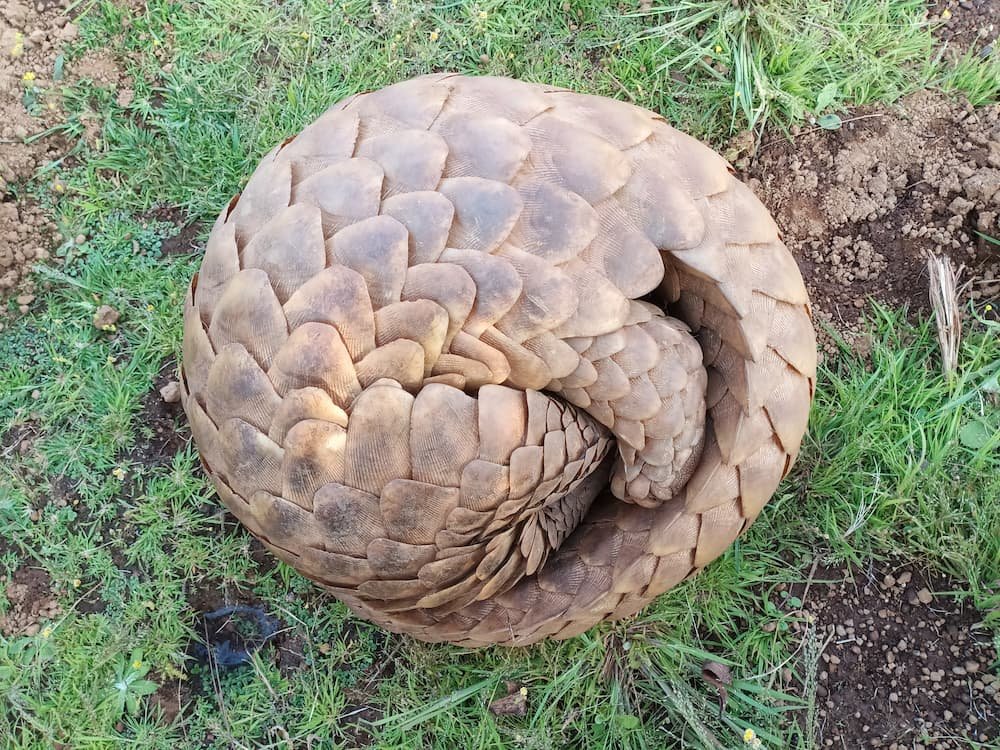
Indian Pangolin (Manis Crassicaudata) is an endangered species, it is placed in the critical category of the IUCN red data list, appendix- I species of CITIES and Schedule -I in wildlife protection act 1927. It is most trafficking animal in the world according to the traffic, but because of the lack of ecological data deficiency create a main challenge for the conservation of species and their habitat, illegal hunting and killing for obtaining the body scale for trade purpose is the biggest reason to the declination of population. Status of pangolin in all our study areas is unknown. Through our projects throwing light on status and distribution of pangolin in the study area, so it will be helpful to prepare of strategy for long term conservation and protection. Also, it is highlighting the threats to the species for their survival. The main purpose of the research projects is to collect the baseline data of the species to prepare the habitat management plan for long term local community based conservation. Creating the awareness about the species in local communities that leads to stop in poaching and become a good opportunity for involvement of people for conservation of the species and their habitat through this activity. Right now we are working in four Sociopolitical landscape of the Maharashtra state, Northern Western Ghat, Marathwada, Khandesh and Vidharbha
1.Melghat Tiger Reserve
Buffer zone of Melghat Tiger Reserve is mainly situated in the Satpura hill ranges of Central India. It lies in Melghat forests of Amravati, Akola and Buldhana district in Vidarbha region of Maharashtra, bordering Madhya Pradesh in the North and East. Its area is geographically located as given below:
Latitude: 210 07′ N and 210 45′ N
Longitude: 760 37′ E and 770 31′ E
Altitude: 312 M to, 1178 M above MSL.
The Melghat Tiger Reserve, owing to its unique flora and floral occurrence and rich bio-diversity, has a very significant place in the conservation history of the State of Maharashtra. The area is well known for its unique topographical diversity, as it is dotted by several high hills and deep valleys, which make it quite secure and everlasting from bio-diversity point of view. The area of the reserve is a typical representative of Central Indian Highland forming a part of the Bio-geographic zone, 6E-Deccan Peninsula-Central Highlands (Roders and Panwar 1988).
Melghat Tiger Project are of deciduous nature and have been classified as “Dry Deciduous Forests” in the Champion and Seth’s “Revised Survey of Forest types of India” and fall under the subgroup 5-A southern tropical dry deciduous forests. The tract being sparsely populated, the biotic factors are less influential except fires which along with general distribution of rainfall, aspect and change in depth and nature of soil are responsible in determining the local variations within the above broad type. Besides receiving less rain fall, the southern part of the region is also subjected to frequent fires, often twice in a year and bear more open forests with species rather resistant to fire. The species with corky bark like Semal (Bombax ceiba) survives the fire and their percentage in the stand increases. Fire and biotic interference have increased the percentage of species like Zizyphus, Stereospermum. Dalbergia Sissoo, and Diospyros in the forests because of their capacity to produce a root sucker, an adventitious shoot, from an extensively branched underground root system.
The teak forests here owe their existence to the remarkable power of these species to withstand repeated burning and to establish itself on burnt grass land. The purity of the present teak forests is largely attributable to the fact that its associates are less resistant, and none of them appears able to establish high forest in periodically burnt area. As the fire sweeps in, the bark of teak, having low conductivity.
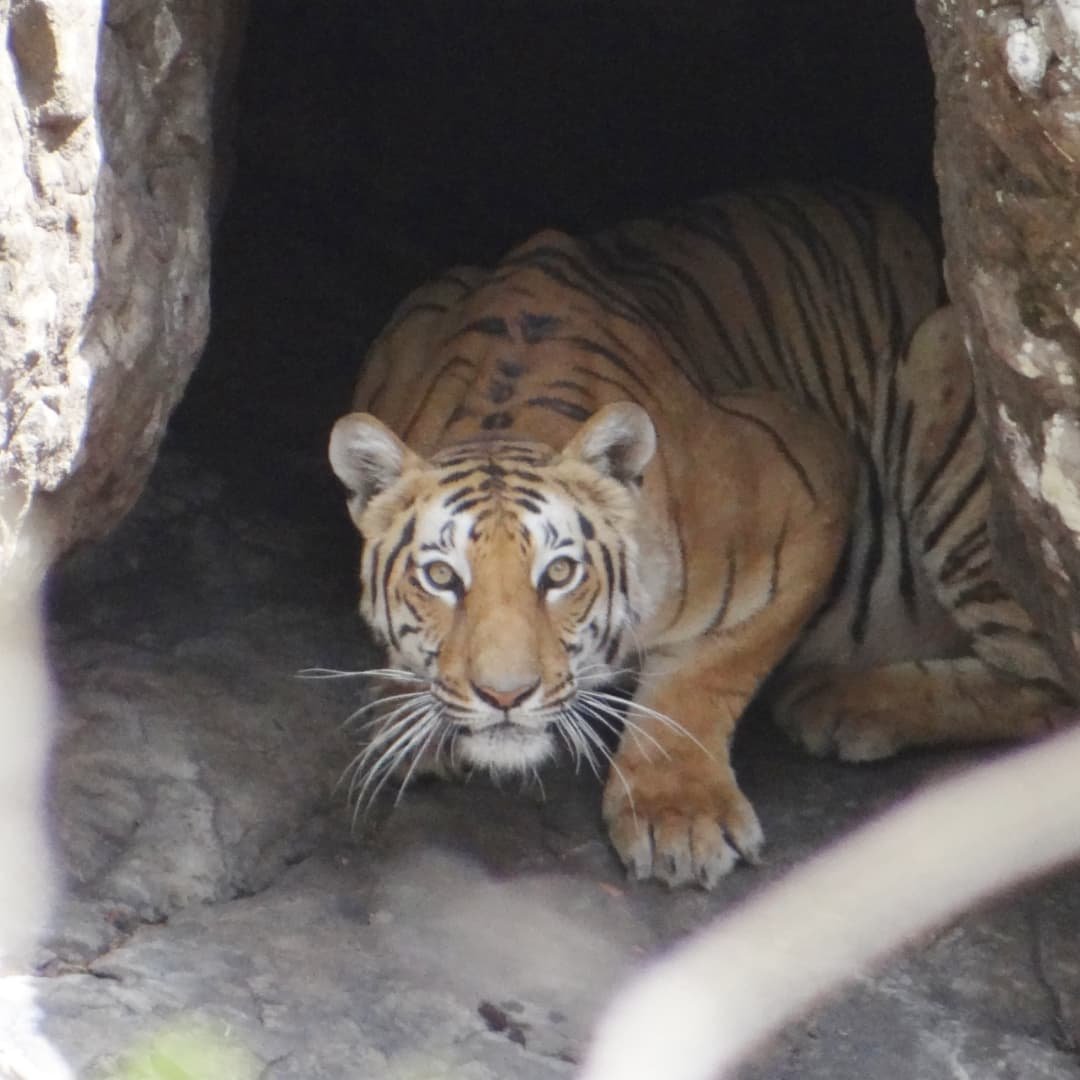
The project has been implementing in the buffer zone of Melghat Tiger Reserve, District Amravati, Maharashtra State, India. Melghat tiger reserve situated in the Satpuda hill ranges of central India and covers the area of 1574.71 Sq.Km. Melghat is the biodiversity hotspot in Satpuda hill ranges where 80 Species of mammals including many endangered species, such as Tiger, Leopard, Indian Gaur, and Pangolin along with mammals,294 bird species found in Melghat including Forest Owlet, once thought to be extinct, has reappeared here in one of the prominent forest of the reserve, where it was rediscovered after a significant gap of many years.
2.Bhimashankar Wildlife Sanctuary:
The project will be implemented in Bhimashankar Wildlife Sanctuary, which is situated in the Northern Western Ghat of the state. Geographically, it is spread over the 130.78 Sq. Km. extends 190 01′ to 190 13′ N latitude and 730 28′ to 730 37′ E longitude at an altitude ranging between 340 m and 1208 m above mean sea level. Bhimashankar Wildlife Sanctuary falls within one of the ten Biogeographical zones of India i.e. code 5 Western Ghats Zone and under the biogeographic province-5B Western Ghats Mountains. The forest of Bhimashankar WLS mainly West coast mix semi evergreen forest covers 99% of sanctuary area which is classified subtype 2A/C2 Bhimashankar is the biodiversity hotspot in Western Ghat hill ranges where 66 Species of mammals including many endangered species, such as Malabar giant squirrel, Leopard, Mouse deer, 236 bird species, 54 reptiles, 9 amphibians, 24 odonata and 65 species of lepidoptera were recorded by Zoological survey of India in Sanctuary area. Along with the biodiversity richness, the sanctuary has 9 tribal villages settled inside.
3.Gautala-Autramghat Wildlife Sanctuary:
Gautala Autramghat Wildlife Sanctuary is a protected forest area of Aurangabad, Maharashtra state, India. Gautala Autramghat wildlife sanctuary, administratively comes under the Aurangabad forest division. It lies in the Satmala, Ajanta hill ranges of the Western Ghats; it is administrated by Forest Authority of Aurangabad and Jalgon District.
The sanctuary was established in 1986 in an existing forest area. Geographically, it is spread over the 277 sq. km area. The sanctuary, owing to its unique flora and floral occurrence and rich bio-diversity, has a very significant place in the conservation history of the State of Maharashtra.
The area is well known for its unique topographical diversity. The area of the sanctuary is a typical representative of Central Indian Highland forming a part of the Bio-geographic zone, 6E-Deccan Peninsula-Central Highlands (Roders and Panwar 1988).
Forest is consisting of deciduous nature and have been classified as “Dry Deciduous Forests and Mix forest along with grassland habitats” fall under the subgroup 5-A southern tropical dry deciduous forests. The forest vegetation is mainly consisting of draught resistant species like, Anjan, Khair and Dhawda. Hills tops have Sparse vegetation.
Slopes are covered with Euphorbia spp. River valleys support moist zone species such as Arjun and Chandan valleys have got diversified vegetation. It is biodiversity hotspot in the landscape, it is providing good shelter for Wild herbivores and carnivores like, Chinkara, Barking deer, Wild boar, Nilgai, Leopard, Sloth bear, Wolf, Jackal, Fox and Hyenas. There are more than 230 species of the birds were recorded. Notably Migrants are Cranes, Spoonbills, Storks, Ibis and many other species of waders.
Peafowl has much dominance in the area in addition to ground birds such as quail, partridges, Jungle fowl. Forest blocks being highly populated, the biotic factors are more influential like fires and grazing which along with general distribution of rainfall. Fire and biotic interference have increased the percentage of species like Zizyphus, Stereospermum. Dalbergia Sissoo, and Diospyros in the forests because of their capacity to produce a root sucker, an adventitious shoot, from an extensively branched underground root system.
4:Yawal Wildlife Sanctuary
Yawal Wildlife Sanctuary is a protected forest area of Jalgaon district, Maharashtra state, India. Yawal wildlife sanctuary, administratively comes under the Nasik wildlife division. It lies in the Satpuda hill ranges. The sanctuary was established in 1969 in an existing forest area.
Geographically it is spread over the 177 sq. km area, Its area is geographically located as given below: 21.25°N–21.06°N and 75.55°–70.09°E Altitude: 400-1074 m above ASL.
Yawal WLS, is located in Jalgaon District at the southern border of Satpura Hills along the northern border of Maharashtra and Madhya Pradesh. Dense bamboo thickets are found in the upper and middle slopes of the hills. Thick undergrowth of Strobilanthes callosa is seen in this area. Along with teak, B. serrata, Acacia catechu, A. latifolia, and Zizyphus mauritiana are found throughout the range. In Yawal WLS, we surveyed Jamnya- and Pal forest ranges. Jamnya Range has mainly teak dominated forests. Pal Range has open forests and grassy undercover. There is preponderance of anjan Hardwickia binata in the region (Shedke & Khairnar 2013). There are three rivers are originating from this forest, viz. Aner, Suki and Manjal and serve as the catchment for these rivers. Yawal Sanctuary play and very important role in dispersal of tigers as the corridor in Satpuda landscape, mainly connects Melghat tiger reserve to Dang region of Gujrat State.
The tribal population is predominantly residing in this area, the tribal belongs to mainly Pawara and community. The local peoples are totally depending on the forest area for grazing, fuel wood and various NTFP like mahua, behead and medicinal herbs. There are four villages settled inside the sanctuary.
The North Western portion of the sanctuary and some part of the Jamnya Range are vulnerable to illicit tree cutting. This area also sharing the state boundary with Madhya Pradesh. The area is well known for its unique topographical diversity. The area of the sanctuary is a typical representative of Central Indian Highland forming a part of the Bio-geographic zone, 6E-Deccan Peninsula-Central Highlands (Roders and Panwar 1988).